

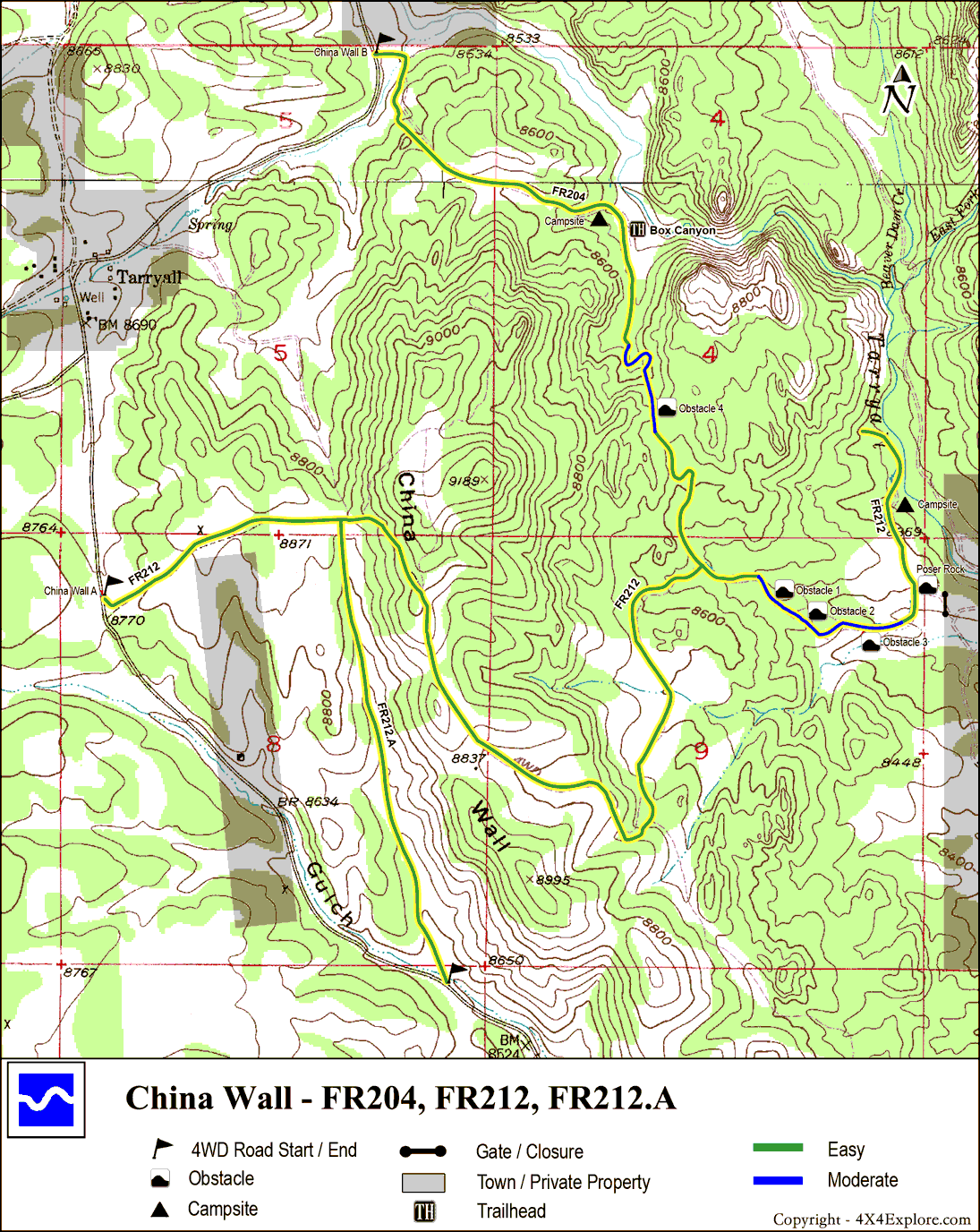
| Difficulty: | Number: | Miles: | Altitude: | Obstacles: | Time: |
|---|---|---|---|---|---|
| Moderate - 5 | FR 212, 204 | 6.5 | 9,040 ft. | Rock - 3 | 1-2 hours |
Colorado Springs, CO 80936
south Park Ranger District
Fairplay, CO 80440
Closure:
July - Best
August - Best
September - May see early snows
October - Possible snow
Accessed:
From Woodland Park, CO. head southwest on US-24 West for 20.8 miles. Turn right onto County Rd 77/Tarryall Road and go 8.0 miles. Keep left at the fork and continue 3.3 miles to a right turn off County Rd 77 onto a dirt road. This is the China Wall 4WD road.

After this connection you will come to a climb that immediately has a left and right turn going around the China Wall. Take the right as it is on the Forest Service Motor Vehicle Use Map (MVUM), the left route is not. After climbing the side of the Wall the road will level out onto a saddle. The road will head down hill toward the north after a sharp turn.
In just over a half mile from the turn you will come to an intersection with FR 204. Taking the right turn will lead you to the rock obstacles. Within a quarter mile the road will drop into a narrow gulch. There will be a few small steps before the main obstacle, a large step with two or three possible lines. After crossing this obstacle the road will climb up and then snake its way down over a small hill. At the bottom there is private property, stay on FR 204.

Poser Rock
As the road heads toward the north through a large area without trees there is a rock slab on the right. This is "Poser Rock", an alternate route. It is a very steep short climb to the top. Once on top it ties back into the main road. The road will continue north heading back into the trees. As you enter the forest again there is a steep down hill section with multiple lines. As the road levels out you will come to a few camping spots near Terryall Creek before the road ends at an old crossing of Terryall Creek.

From here back track to the intersection of FR 204 and FR 212. Continue on FR 204 to the north. The road will wind through the forest and pas some large boulders. In about 1/3 of a mile the road will wind through some large rocks and down a steep switchback before passing the Box Canyon trail head. Shortly after the trail head the road will intersect with County Road 77.