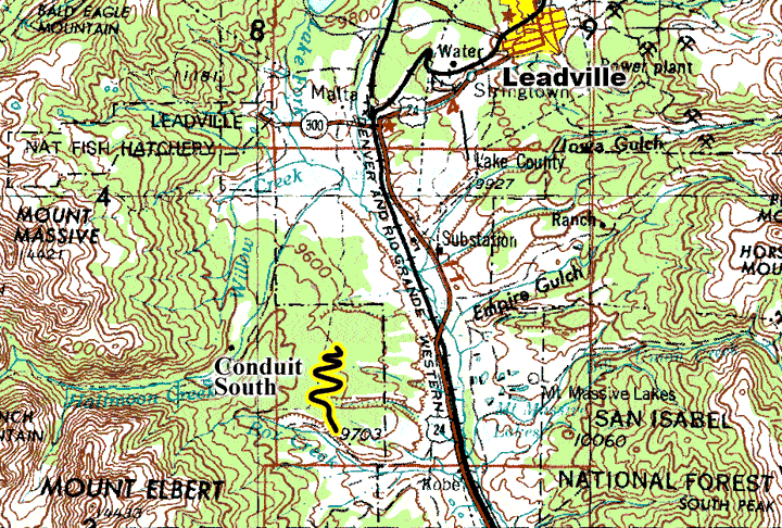
Conduit South  |
| Maps: |


|
| USGS 7.5' Map: |
Leadville South |
| Statistics: |
| Difficulty: |
Number: |
Miles: |
Altitude: |
Obstacles: |
Time: |
| Graded |
FR 130.S |
2.08 |
9,700 ft. |
None |
45 min |
|
| County: |
Lake |
| Adopted by: |
|
|
|
| Managed by: |
San Isabel National Forest,
Leadville Ranger District |
810 Front Street
Leadville, CO 80461 |
719-486-0749 |
| Summary: |
Conduit South follows a buried water pipeline. |
| Attractions: |
Camping |
Seasonal
Closure: |
Agency - December 2 to May 31 |
| Best Time: |
June - Best
July - Best
August - Best
September - Best
October - Early snows may block the road |
Trail Heads
Accessed: |
|
| Camping: |
There are dispersed campsites along the middle section of the road. |
| Base Camp: |
This would be a good area to base camp and explore the 4WD roads and hiking trails around Twin Lakes. |
| Fall Colors: |
Poor - Mainly pine forest. |
| Navigation: |
From Leadville, CO head south on Harrison Ave toward E 6th Street for 0.4 miles. Continue onto Silver Drive for 0.3 miles. Continue to follow US-24 E for 7.9 miles. Turn right onto County Road 10 and go 0.1 miles. Turn right toward Forest Road 130 for 361 feet. Slight left onto Forest Road 130, then go 1.6 miles. Turn left onto Forest Road 130.B.
From Buena Vista, CO head north on US-24 W toward W Sterling Ave for 25.6 miles. Turn left onto County Road 10 and go 0.1 miles. Turn right toward Forest Road 130 for 361 feet. Slight left onto Forest Road 130, then go 1.6 miles. Turn left onto Forest Road 130.B.
|
| History: |
|
| Description: |
Starting from the four way intersection you will head south following the buried Mount Elbert water pipeline (conduit). The pipeline is part of the Fryingpan-Arkansas water development project. Mount Elbert Forebay reservoir receives water through the Mt. Elbert conduit from Turquoise Lake and has been operational since 1984. Hydroelectric power is produced at the outlet of Turquoise Lake and at the lower Twin Lakes power plant. The Twin Lakes power plant can pump water to the Mount Elbert Forebay reservoir where it is released back to lower Twin Lakes for power generation. The road is graded and follows the treeless swath where the buried conduit is. Just after starting south you will come to an intersection with a faint road to the left that is not a legal route. Taking the right you will head west and down into an unnamed gully. The road will cross the gully and head back up into the forest climbing back toward the conduit. Just before reaching the top, and the conduit, you will pass a campsite on your right. After reaching the top where, the conduit swath is, you will again head west down into another gully. Where the road crosses the head of the gully you will pass a road on the right that goes to a thinned area of the forest. The main road heads to the left and begins its climb back up to the conduit swath again. About half way to the top of the ridge you will pass another campsite on your right.
This time the road will follow the conduit swath for a while before coming to the more substantial Sage Draw. The road will pass through an area of the forest that has been thinned in the past. At the edge of Sage Draw there will be a campsite on the right. Here the road will once again head down into the gully of Sage Draw. Just before reaching the floor of Sage Draw you will come to a road on the left. This is Sage Draw, FR136, which heads down the gully. Continue on FR130.B and cross the gully, then climb up the south side to once again connect with the conduit. After a short distance you will come to a road to the right that heads west into the forest, going to other thinned areas. Stay left, or straight ahead. Immediatley you come to another intersection. The road straight ahead follows the conduit, but is not a legal route. Take the left into the trees. You will pass a thinned area of the forest on your left. As the road comes out into an opening there will be a spur road to the left that is not a legal route. Stay to the right. You will come to a four way intersection. The roads to the left, and straight ahead will head onto BLM lands, and are unnumberd. Stay to the right again and head south. As you come to the trees again you will be at a large Y in the road. This is the end of Conduit South. The road to the left is Chlober Hill, FR130.C, the road to the right is Doc's, FR130.D.
|
|
Data updated - February 1, 2021
4WD Road driven - September 7, 2020
Copyright 4X4Explore.com - 2000-2021 |