

| Difficulty: | Number: | Miles: | Altitude: | Obstacles: | Time: |
|---|---|---|---|---|---|
| Graded | CR124 | 10.23 | 8,170 to 11,760 ft. | NA | 2-3 hours |
Closure:
June - Best
July - Best
August - Best
September - Best
October - Good
Accessed:
From Cortez, CO head east on US-160 E/W Main Street toward S Market Street. Continue to follow US-160 E for 33.9 miles. Turn left County Road 124 and go 4.3 miles passing through Mayday CO. The county road will then turn to gravel.
Captain John Moss and C. D. Posten left the California gold fields in 1856 and searched the mouth of the La Plata River. Here they found good placer gold. Moss returned in the summer of 1873 with a group of prospectors from California. The group found gold, and quartz, indicating the possibility of lode mines. With provisions running low the group headed to the nearest trading post, 130 miles away. While on this trip for provisions, Captain Moss made a treaty with Ignacio, chief of the Sothern Utes, which allowed them to mine and farm an area 36 miles square in return for 100 ponies and lots of blankets. This 36 square mile area encompassed the La Plata River canyon. With a copy of the treaty and samples of the gold quartz, Moss went to San Fancisco and showed them to Tirbircio Parrot, a banker. Parrot was very interested and told Moss to outfit a party and head back using his finances to fund it.
In the fall of 1873 a group from a group from Arizona headed for the same mountains that Moss had explored. By November the Arizona group reached the river valley and bagan washing out good gold. The winter drove them out, but by May of 1874 they had returned and began digging ditches and building sluices to mine the gravels of the river. Moss and his group made it to the Mancos River by April of 1874, but were stopped by deep snow. By the middle of May they reached the La Plata River again, only to find the Arizona group working it. The two groups had a meeting and agreed to work together. Each group staked off 20 acres. Moss and his group laid out Parrot City and build a blacksmith shop.
Both groups set to work building ditches and flumes to bring water to the placers for washing gold out of the gravels. Later, hydraulics were used to wash out the river banks. The first lode mine was the Comstock, three miles north of Parrot City. This began the efforts in lode mining which ended up producing over twenty developed mines in the canyon. Silver was also mined in this area. By 1881 the population of the area had grown to over three hundred and Parrot City was the county seat. With Durango growing, and the Denver and Rio Grande railroad reaching the town, plus the construction of smelters to process the ore, Parrot City lost out the Durango as the county seat in short order.
La Plata City got its start when the prospectors followed the placer gold up the La Plata River. By 1882 La Plata City had a population of 200. Lode mining began to take over as the miners found the source of the gold in the river. La Plata City got its post office in 1882 being called "La Plata". In 1885 the post office was closed. By 1889 the population was close to 500. In 1894 the post office was reopened as "LaPlata" and it remained until 1934. La Plata City boasted a business district with false front stores, residences, and a school house.
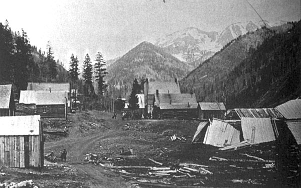 |
La Plata looking north northeast - early 1900s |
|---|
The Comstock vein was discovered in 1873 by A.K. Fleming, who along with Captain John Moss and Harry Lightlner staked staked north and south Comstock claims in 1874. The Comstock is credited as the first discovery in the district. The claims were sold to Tirbircio Parrott in 1875. A shaft and three drifts were opened by 1881, but the mine was inactive from 1885 to the late 1890's. The Comstock had intermittent production from 1904 to 1931, afterwhich it was shut down.
North of La Plata City was a mining camp called Cumberland. The Cumberland and Snowstorm deposits were discovered in 1878. The produced little ore until 1884. After this significant production began. During the late 1880's, a 30 stamp mill was built, but it was not suited for treating the ore from the Cumberland mine. The mine was idle in the 1890's, but it was revived in 1900 and then again in 1909. The mill and other surface buildings were in ruins by 1937. Today only the steam boilers remain.
By the late 1800s and early 1900s large mine complexes were being developed in the La Plata River valley, like the May Day, Comstock, Cumberland, Gold King, Idaho and La Plata. These produced record amounts of gold, but as always were soon abandonded due to high operation costs.
The Bessie G. Mine was discovered in 1880 under the name of Egyptian Queen, and renamed the Bessie G. when the claim was patented in 1891. The mine was worked intermittently through out its operation. The La Plata Gold Mining Corporation of Salt Lake City spent $150,000 to reopen the Bessie G Mine. It produced over $750,000 in profits before being closed in 1955. Then in 1983 Sierra Resources made and agreement with EXXON for exploration of the property. Underground development began and a mill was under construction in late 1983. No further activity has happened since.
The Bonnie Girl mine was discovered in 1895 and produced small amounts of gold ore until 1902. Production was intermittent in 1906, 1908, AND 1919. Around 1904, a 50 stamp mill was built at the mouth of Tirbircio Creek, connecting to the mine by an aerial tram. The mill only operated for a few years. By 1919 production at the Bonnie Girl had ended.
Th Gold King vein was discovered by Basil Caramouzis in 1921. In 1927 La Plata Mines Co. bought the property and rebuilt the old Bonnie Girl Mill, added jaw crusher, tube and ball mills, and flotation cells. The also built an 8,000 foot long aerial tram from the mine to the mill. The mill produced concentrates from 1928 to 1935. Difficulties foreced the mine to move to a trusteeship for operation. The Fawn Mining Co. operated the mine from 1936 to 1937, until the ore pinched out, forcing the shutdown of the mine. In the early 1940's the last activity at the mine was some exploration and sampling work.
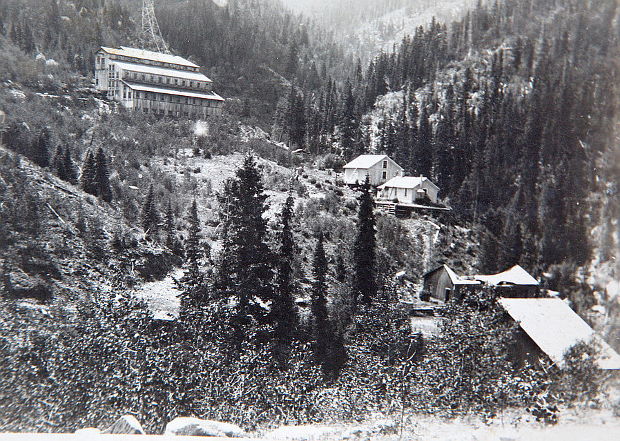 |
Gold King Mill - 1932 |
|---|
Wolle, Muriel Sibell. Stampede to Timberline Athens, Ohio: Swallow Press, 1949. Print.
Eberhart, Perry. Colorado Ghost Towns and Mining Camps Athens, Ohio: Swallow Press, 1959. Print.
Jessen, Kenneth. Ghost Towns, Colorado Style. Volume 3 - Southern Region Loveland, Colorado: V. J. Publications, 2001. Print.
Western Mining History, website.
From the Madden Creek Campground, CR124 will head northeast before turning north again. Here you will start to pass private homes as you come into La Plata City. The next intersection is a road on the left, South Bedrock Creek, FR792 and FR796. Continue on CR124 you will cross the Bedrock Creek drainage. The very next left is North Bedrock Creek, FR793. Continuing on there will be more private homes and a right turn off the county road that goes to the La Plata City Campground, which is primitive with no facilities. If you turn here the road will loop back to the southwest. Look for a wide spot with a left turn that will take you down and across the La Plata River. This is Nepturn Creek, FR797, which does a never ending series of short switchbacks up the side of Deadwood Mountain.
Continuing on CR124 you will pass through the main part of La Plata City. It is no longer a ghost town, with repaired cabins and some new structures. Just past town you will come to another intersection. There will be a private driveway on the right and Boren Creek, FR794, to the left. The county road contiues for a while with not side roads, and then heads east as it rounds a corner. There will be a wide pull off on the right as you head back north. From here you can look across the river up into Tirbircio Gulch and see the foundations of the Gold King Mill. Next you will come to a rock lined driveway on your right. A short distance from the driveway is another right turn to the Lewis Creek Campground, which is also primitive. Continuing on CR124 you will come to another spur road to the right which goes down toward the river.
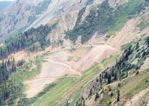
Staying on CR124 you will cross over Basin Creek and then come to a road going off to the left. This is Basin Creek, FR798, which goes up to Tomahawk Basin. Next you will come to a road going off the the right. This is the Darby Creek Campground, also primitive. The county road will contiue along the river for a while before coming to a road going off the right again. This is the Columbus Basin Road, FR498. Continuing on CR124 you will quickly come to a right turn that goes into the Ruby Campground, a small primitive campground. From here CR124 becomes a bit narrower and less maintained as it climbs into, and then out of Cumberland Basin.
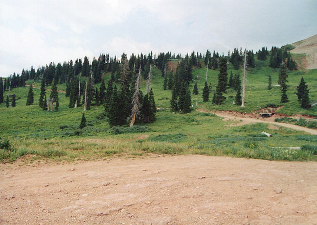 |
Cumberland Basin photo by: Adam M |
|---|
You will climb up a few switchbacks before coming out into a wide flat area with few trees. The two boilers along the side of the road are from the Cumberland Mine and Mill that use to be here.
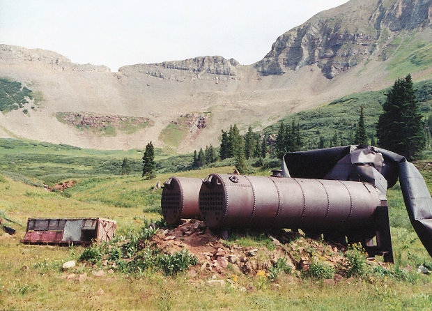 |
Boilers at the Cumberland Mill site photo by: Adam M |
|---|
Continuing, you will come to a saddle at about 11,620 feet with a large parking area. This is the trail head for the Colorado Trail. To your east is Kennebec Pass. To the southeast is Cumberland Mountain at 12,388 feet.
The county road continues from here along the side of Cumberland Mountain to the saddle between Cumberland Mountain and Snowstorm Peak, getting you to 12,020 feet, before the road ends. From the saddle you can look down into Heffernan Gulch. Straight south of the end of the road, you can follow the old road over to the Bessie G. Mine below Snowstorm Peak.
 |
View over to the Bessie G. Mine photo by: Adam M |
|---|