

| Difficulty: | Number: | Miles: | Altitude: | Obstacles: | Time: |
|---|---|---|---|---|---|
| Easy 4 | FR839 | 9.74 | 9,680 to 11,500 ft. | NA | 2-3 hours |
Gunnison Ranger District
Gunnison, CO 81230
Closure:
July - Possible opening depending on snow level
August - Best
September - Best
October - Early in the month
Accessed:
The tunnel was open from 1881 to 1888 during the summer months due to the winter weather and difficulty of keeping the snow off the tracks. Because of the winter snows, 150 feet of snow shed were built on the east side, and 650 feet on the west side, to keep the tracks clear. A rock slide on the east side closed the tunnel in 1888 and it was not re-opened until 1895. From then on the cost of keeping the trains running and the slow down of mining was too much, and in October of 1910 the Alpine Tunnel closed.
Just west of the west portal of the tunnel was Alpine Station. It was the service area for the trains and railroad grade. There use to be a large stone engine house, built in 1881, that could house 6 locomotives. It was 54 feet by 153 feet. There were also coal bins, a 9,000 gallon water tank, bunkhouse, store and the telegraph office. A fifty foot Armstrong turntable and a switch were also added. In 1906 a fire swept through Alpine Station and all of the buildings were destroyed. Because the buildings were built without mortar they collapsed in the fire. In September of 1906 a new boarding house was built. Suddenly, in 1910, the Alpine Tunnel caved in. At the time a work crew was in the tunnel and the coal smoke dust overcame four or five of the workers. These were the only casualties during the construction and use of the Alpine Tunnel. Shortly after the cave in, the tracks were removed as profits from this high railroad were countered by the cost of snow removal during the winter months.
Below Alpine Station is the famous Rock Palisades. They were constructed of hand cut mortarless rocks forming a 452 foot long, 33 foot high, and 2 feet thick support for the railroad tracks.
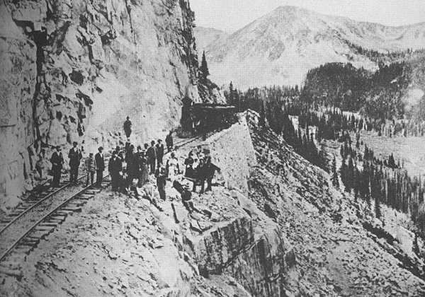 |
Rock Palisades, train is sitting on the main palisade |
|---|
At 11,000 feet, just below the Alpine Tunnel, the town of Sherrod sprang up in 1903 when prospectors discovered rich gold and silver deposits. By mid year of 1904 there were two hotels, a loading station, cabins, many tents, a depot and a newspaper. This was a short lived boom though. By 1906 Sherrod was a ghost town.
Below Sherrod near Pitkin the town of Woodstock started as a silver camp in 1881 but with the railroad building along Quartz Creek it became a railroad town of the Denver and South Park Railroad. By 1882 the camp had become a town with a boarding house, telegraph station, water tank, cabins, and a restaurant. On March 10, 1884 Woodstock was devastated by an avalanche, the white death, when 14 of the 17 residents were killed. The town was not rebuilt but a water tank was put up 1/2 mile down grade at Tunnel Gulch.
In 1964 Gunnison County built a bridge across Quartz Creek just north of Pitkin. This allowed travelers access to Alpine Tunnel over the old railroad grade.
Gunnison County Chamber of Commerce Ghost Towns and 20 Circle Tour trips of the Gunnison County Gunnison, Colorado: B&B printers. Print.
Brown, Robert L. Ghost Towns of the Colorado Rockies Caldwell, Ohio: The Caxton Printers, 1968. Print.
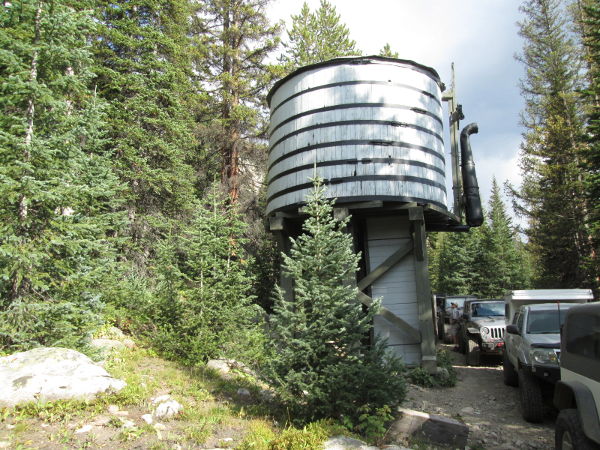 |
Remaining water tank near Tunnel Gulch photo by: Adam M |
|---|
About 500 feet above the water tank are the Palisades. The road will continue to follow Middle Quartz Creek as it loops around to the south. From here there are a few spur roads that go down to the creek as access for camp sites. You will come to a large hairpin turn with an intersection to the right. The road to the right heads into Brittle Silver Basin and accesses Tomichi Pass, FR888, and Hancock Pass, FR266. The old railroad grade actually went further to the south forming a broader loop. Stay to the left to continue on the Alpine Tunnel road.
In 2017 a rock slide had damaged the Palisades and the road was closed at this point.
The road will climb along the side of Mount Chapman heading north to cross the gulch above the water tank. Once around the gulch you will come to the sheer section with the Palisades supporting the road. From here you will follow Tunnel Gulch up to the site of Alpine Station and the wester portal of the tunnel.
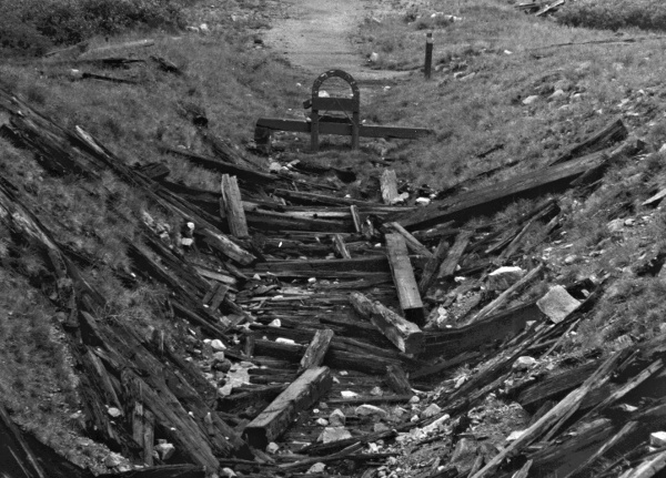 |
Collapsed west entrance to the Alpine Tunnel, 1989 photo by: Adam M |
|---|